|
| Thread: Your local History |  This thread is pages long: 1 2 3 · NEXT» This thread is pages long: 1 2 3 · NEXT» |
|
privatehudson


Responsible
Legendary Hero
The Ultimate Badass
|
 posted March 24, 2004 12:25 AM
 |
bonus applied. |
|
Your local History
In another forum I once had this idea for a thread about gathering together as many "local" histories as possible. Each would be a member's local town, or city, or region, or whatever matters to them. I tried to set it up so that people would post stuff like History, pictures, maps and so on, describe the area a little etc. Then others could comment, ask questions and so on 
So I thought I'd try it here 
The Wirral
I chose to write about the smal peninsula that I live on in England called the Wirral. Lying between Liverpool and North Wales, and flanked by the Mersey and Dee Estuaries, the area has been vital for trade and transport since the time of the romans. A map of it's location follows:

A closer map of the Wirral itself is following

History:
The wirral has always been important to the North West of England, and in the past far more so than neighbouring Liverpool. The romans had a large base neaby at chester (which they called Deva) and possibly used the wirral for trading with Ireland. The area has a mixed past after the romans left, for a time the Saxons occupied land in the area alongside the western side, flanked by the Dee estury and later the Vikings arrived and settled areas throughout the peninsula. During much of the history, the peninsula remained mostly farmland and fishing industries except around what is now Port Sunlight and Thornton Hough which was marshland. The peninsula also gets numerous mentions in the doomsday book, Wiliam the conqueror's census.
The Wirral has always been important to travel as it lies right between Wales, Ireland and England, and in the 1300's, a charter to operate ferries was granted to run between Liverpool and Birkenhead. Liverpool though was at this stage little more than a small hamlet, whilst the Wirral was a thriving farmland area. Things continued in this line until the start of the industrial era around 1800 which changed the area for good. For one, Liverpool saw rapid change, founded on the principle of the slave trade and then the merchant trade. Wirral though became the first stop for raw goods coming into the area before being transported eastwards in the direction of Manchester and so on, often via canal boat.
Originally, the Dee estuary was used as the route for shipping, but gradually this route became silted up badly and the shipping switched to the Mersey side of the peninsula. The rise in importance of the area saw many new industrialists take interest in the peninsula, two of them would make a considerable contribution to the Wirral.
John Laird:
A ship-builder by trade, he came to the area in 1824 and bought large areas of what is now known as Birkenhead and built an ironworks on the land. Laird expanded his business dramatically on the site and Birkenhead and Wallasey expanded with it. Laird merged his company eventually with another called Cammell to produce a massive ship building site in the Tranmere and Rock Ferry areas. During it's time, the yards produced the biggest British carrier of WWII, the Ark Royal and one of our famous battleships, the Prince of Wales. Pictures of these are below. The yard also built many nuclear powered submarines for recent service. Now, unfortunately it has been closed.


William Hesketh Lever:
Lever was the founder of the Lever Brothers empire, now known AFAIK as Lever Faberge, a worldwide company making detergents and soaps. Lever was the first in the country to perfect the mass production of soap from sources that didn't make the soap smell awful and made a fortune on it from a factory and shop in Bolton. Sometime in the latter part of the 19th century he realised the benefit of opening a factory nearer to where his imported goods reached the country in the Wirral and looked for land there to buy. Seeing the marshland around Port Sunlight, Lever bought most of the land there.
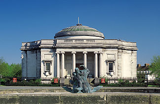
Lever then built an entire village named after one of his then principle products, (sunlight soap) Port Sunlight. He constructed the village for all his workers as a working man's paridise, with a school (which BTW I attended), pub, sports hall, church and so on. The entire village was built in an old style based on similar buildings in chester and other areas. By and large the village has remained almost exactly the same ever since. Lever also built an extensive art gallery which he dedicated to his wife within the village. A picture of this is below.
And some of those houses:

The prosperity of the area in the 19th century continued until well into the 20th, the Wirral being an important part of the port traffic coming into Liverpool. In the mid 19th century, the Birkenhead docks were built to support this and the expansion of Birkenhead as a town. As the Mersey became more and more important, increasing numbers of people moved to the east coast of the Wirral. This increase swamped the available ferries in demand and by 1886 the very first underwater railway in the world was built between the Wirral and Liverpool connecting both Wallasey and Birkenhead to the larger city nearby.
During the war, the Wirral was frequently bombed by the Germans due to it's docks and connection to shipbuilding causing a major refit to the roads in the areas of Birkenhead and Wallasey. Eastham also contans a major fuel storage area now which was also a target then. The decline in merchant shipping and Britain's economy after the war though hit the Wirral hard, yards like Cammell Lairds slowed production and eventually closed, Lever's were forced to close much of their other work in the area and so on. Though still an important area (almost equal in population to Liverpool), the Wirral's economy has struggled in certain areas such as seacombe and others since the war. Other areas, mostly those on the western side have prospered. Wirral remains quite a nice area, most of the western half is farmland and golf courses (the British open is here in a few years) with the eastern half industrialised.
Famous/Strange things:
The first hovercraft tests in the world were carried out from the beach at New Brighton
The Beatles frequently played on this side of the Mersey before their stint in Hamburg
The main park in Birkenhead, Central Park is a small scale version of the more famous one in New York, the Birkenhead one is older and apparently, the New York one is modelled on it!
The symbol of the Wirral is a hunting horn, this is to signify our link to the past as since the romans, the area was covered in Forest and used by nobles for hunting in.
During the American Civil War, Laird built for the confederates 3 surface raiders (1 only was delivered) which were frequent visitors to these shores. He was due to build 5 but the British government found out and stopped him. The CSS Alabama had a notorious reputation sinking 36 ships before being sunk. The US government promptly took the UK government to court for building and helping the ship and others and won!
There have recently been installed a number of historic warships in the Birkenhead docks. The collection comprises HMS Plymouth, a type 42 Destroyer and HMS Onyx, a submarine, LCT7074, possibly the only surviving Landing Craft Tank from D-Day, and U534, this is the only wartime U-boat raised and put on display. Onyx and Plymouth are Falklands era ships. U534 was one of the last U-boats sunk in the war just off Denmark by the British, though it's said that no-one died on board her.
Sports wise, we have 1 professional football club on the Wirral called Tranmere Rovers. Here is a pic of their ground. They play in a relatively minor league, but this season might do really well in the FA cup

I live in Rock Ferry, a small village on the eastern coast of the Wirral, about half way up. I work in Wallasey, Liscard to be precise and went to school in Bebington and Port Sunlight. My family are mostly either from Liverpool, Wales or Wallasey. I myself was born in New Ferry, just a little down from where I live now.
Some Wirral links:
http://members.tripod.com/wirral_rf/
http://www.wirralview.co.uk/
Well, that was me. I'm sorry I waffled, you don't have to do this much don't worry! The idea simply was to get to know a little more about other people's countries or regions through information on them
____________
We're on an express elevator to Hell, goin' down!
|
|
regnus_khan

Responsible
Supreme Hero
[ Peacekeeper of Equilibris ]
|
|
posted March 24, 2004 08:29 PM |
|
|
Local history of Vilnius and Kaunas
First version of Vilnius history (net):
The foundation of Vilnius
Vilnius is the capital of Lithuania and one of the country's oldest cities. It stretches along both banks of the fast flowing Neris River, and is set among hills with pine forests. Vilnius is a very old city indeed. The name of Vilnius derives from the name of stream Vilnia which flows right across the heart of the city. Archaeological excavations have revealed that people inhabited the valley at the Gediminas Hill on the confluence of the Vilnia and Neris rivers as early as the l-st century A. D. Traditionally, however, the foundation of a city is traced back to the first official mentioning of the city's name. The honour for founding Vilnius is justly given to Gediminas (a Lithuanian Duke) in the year 1323. According to the Lithuanian Folk Culture Centre, here is the myth about the foundation of Vilnius
At first the Lithuanian capital was Kernave. But having found a beautiful place on a group of lakes during one of his hunts, Grand Duke Gediminas founded Trakai and moved his capital there. Soon after that he went on a hunt again and four miles away from Trakai, on a beautiful hill on the shore of the Vilnia river, he shot a huge aurochs. Since that time the hill has been known as Aurochs Hill. It was too late to return to Trakai, and the Grand Duke camped for the night in the Sventaragis valley on the Vilnia river, the sacred place where Lithuanian dukes used to be cremated. In his sleep Gediminas had a dream: he dreamed an iron-clad wolf which was standing at the top of the Crooked Hill (now called the Bald Hill) and howling as if there were a hundred wolves inside it. The High Priest, Lizdeika, interpreted the dream for the Grand Duke in the following way: the iron-clad wolf meant that Grand Duke was going to build a city, his future capital, at the foot of the hill. The howling of the wolf meant that the fame of the city would spread far and wide in the world.
Grand Duke Gediminas collected a great number of people and built two castles - the Lower castle in Sventaragis valley and the Upper castle at the top of Crooked Hill. He gave the city around the castles the name of Vilnius and transferred his capital there.
The legend has great deal of truth in it. In 1985 archaeologists uncovered the remnants of the ancient pagan temple which had stood right on the site of the present Cathedral.
Having declared Vilnius his "royal town", Gediminas created the conditions for its subsequent growth as the political, economical and cultural centre of Lithuania. The fortress on Castle Hill was used for defense purposes and was called the Upper Castle.
Old Vilnius emerged over hundreds of years, expanding, changing, and embodying the creative imagination and experience of many generations of architects and builders from Lithuania and abroad; under the care of generous and perceptive benefactors, it became a city rich in architectural treasures and urban harmony.
Following the craftsmen in other European towns at the end of the 15th century, Vilnius craftsmen began to join together by professions into guilds. Many Catholic churches and monasteries appeared in the town. Stone buildings sprang up inside the Lower Castle. The new Cathedral was among them. Crafts and trade continued to develop in the 16th century. Many beautiful new buildings in the late Gothic and Renaissance style appeared in the town. The most significant event in the cultural life of 16th century Lithuania was the founding of the Vilnius Academy in 1579, which was endowed with the rights and privileges of a university. In 1795 Vilnius became the centre of a new gubernia consisting of the lands annexed to the Russian Empire. A number of new Classical style buildings were built, including the Cathedral, which had been reconstructed at the end of the 18th century, a new town hall, and the Governor-Generals' Palace. In 1860, a railway, the first in Lithuania, crossed Vilnius and connected with St. Petersburg and Warsaw.
During World War I Vilnius was occupied by the Kaiser's troops for three and a half years. On 16 February, 1918, Lithuanian Council in Vilnius proclaimed an independent Lithuanian Republic. In the autumn of 1920, Vilnius and the region to which it belonged were occupied by Poland. On October 10th, 1939, Lithuania and the Soviet Union signed a treaty on mutual aid, in accordance with which Vilnius and the Vilnius Region were returned to Lithuania. In 1940, Vilnius became the capital of Soviet Lithuania, which meant it was an administrative centre of occupied Lithuania.
On March 11th, 1990, the Supreme Council restored Lithuania's independence.
Parents edited version:
Vilnius is not only the largest town of Lithuania but it is the capital of the republic too. It is situated by the confluence of the rivers Neris and Vilnia in a strictly cut and hilly place. The Neris divides the town into two parts. It is thought that the name of Vilnius is derived from the Vilnia stream that flows into the Neris. The founder of Vilnius is considered to be the Grand Duke of Lithuania Gediminas. The name of Vilnius was mentioned in the written chronicles for the first time in Gediminas' letter to the towns of Western Europe in 1323.
The Vilnius settlement started from the contemporary hill of the castle - a 48 metres high rectangle hill by the confluence of the rivers Neris and Vilnia. It is a very old mound of Lithuanian-Baltic tribes which had lived in the 1st thousand years. Before moving the capital from Trakai to Vilnius a wooden castle stood on that hill and quite a big settlement was situated at the foot of it. In the written chronicles of that time the castle was called the Upper castle. It is one of the architectural monuments of Gothic style in Lithuania.
and Kaunas's history:
KAUNAS
City of confluence
Kaunas is the second largest city in Lithuania, first mentioned in an old manuscript of 1361. It is situated in the valley of two longest rivers of Lithuania, the Nemunas and the Neris.
The town itself became an example of a confluence of people and cultures, an attractive blend of architecture and nature.
The town has seen many ups and downs, but has stayed a source of forces for resistance, a guard of national identity, and has once actually been the temporal capital of Lithuania.
Fragments of the past
Much earlier, until the beginning of the 15th Century, Kaunas Old Castle was an important resistance post against the attacks of the Teutonic Order. After the victory of joint Lithuanian-Polish forces in the Zalgiris (Grunwald) battle in 1410, during the reign of Vytautas the Great, the Grand Duke of Lithuania (1392-1430), the period of true prosperity started. At that time Lithuania had already acquired Christianity. Kaunas was given the Magdeburg rights and enjoyed the years of development in trade, crafts, culture, and extensive contacts with Western Europe.
In a stroll around the Old Town one encounters numerous fragments of late Gothic. It can be seen in fortification, e.g. the Old Castle, religion and in public-and dwelling buildings.
In many places Gothic gave way to later architectural trends. Manifestations of the Renaissance style can be found in the architecture of Holy Trinity Church and the Monastery. When Baroque style started to dominate in the Lithuanian-Polish state, Lithuania lived through a contradictory period. The splendid churches and monasteries marked the victory of Catholicism over Reformation movement. But an Evangelical-Lutheran Church, a a nice example of the late Renaissance period, survives inside the Old town.
The result of the hard wars with neighbouring countries was the final division of the state Lithuania-Polish in favour of Russia, Prussia and Austria, in 1795. Kaunas and the largest part of Lithuania were subordinated to Russian Empire for more than one century.
Nevertheless, during the 17th to 18th Centuries a lot of splendid Baroque buildings were erected in Lithuania. A Baroque interior is characteristic of many Gothic churches of Kaunas. The city symbol, the white Town Hall, is mainly Baroque, possessing trends of the Gothic, Renaissance and Classicism. As Kaunas itself, it accumulated the best features of its Golden Ages.
Sorry to post sp much stuff. There are links where you can find same and more about towns of Lithuania:
http://discovery.ot.lt/cfair98/kaunas/kau_isto.htm
There will be hyperlinks to some other towns if it interests ya.
____________
|
|
Consis

Honorable
Legendary Hero
Of Ruby
|
 posted March 24, 2004 08:51 PM
 |
|
Edited By: Consis on 25 Mar 2004
|
Portland&Beaverton, Oregon
Oregon state History(general overview)
About thirteen thousand years ago the first native Americans had arrived in the Northwest from Mongolia by way of Siberia and Alaska. The Indian pictographs on canyon walls and legends of the Northwest's earliest historic accounts provide the story of how Oregon was shaped by the ocean, volcanoes and rain. Many Oregon names are derived from Indian tribal names, such as Multnomah, Willamette, Siuslaw and Clackamas.
The native Americans were followed many centuries later by Spanish and British mariners seeking the fabled "great river of the west." Spanish and English sailors are believed to have sighted the Oregon coast in the 1500s and 1600s. It was an American, however, Captain John Gray, who in 1792 discovered the great river and named it for his ship, The Columbia. Captain Gray was one of the first white men to enter Oregon. Capt. James Cook, seeking the Northwest Passage, charted some of the coastline in 1778.
This discovery prompted Thomas Jefferson in 1804 to send the exploring team of Lewis and Clark overland to gain more knowledge of the region and to find out if there was a northwest passage. In 1805 the Lewis and Clark expedition explored the area. They found that the passage did not exist, but laid claim to the territory. Their expedition, along with Captain Gray's trip, gave the United States a strong stake in the land.
Early trappers and fur traders made exciting explorations, finding the bounty that Oregon provided. The British Hudson's Bay Company, led by Dr. John McLoughlin, became the dominant force in the economy. This fur-trading company directed activities throughout the region and built the original capital of the Oregon Territory in Oregon City at the northern end of the Willamette Valley. John Jacob Astor's fur depot, Astoria, was founded in 1811.
It wasn't until the 1840s, however, that the main influx of people began. Pioneers from the East Coast border states and merchants traveling by ship from New England increased the Oregon population, leading to the creation of the Oregon Territory in 1848 and statehood in 1859. Disputes for control of Oregon between American settlers and the Hudson Bay Company were finally resolved in the 1846 Oregon Treaty in which Great Britain gave up claims to the region.
The emigrants, traveling by wagon, crossed the Oregon Trail from 1841 to 1860, covering 2,000 miles from Missouri to Western Oregon. The majority of the pioneers settled in the fertile Willamette Valley. Discoveries of gold on the coast and in the high country led to settlement in these regions as well. These latter settlements, however, provoked tragic Indian wars which lasted many years. The Rogue River, Modoc, Paiute, Bannock and Nez Perce Indian wars all concluded with the Indians surrendering their land.
When the railroads came to Oregon in the 1870s the agriculture industry no longer required direct access to waterways because supplies could be transported overland. The arrival of the automobile quickened the urban growth of the state, and the depletion of eastern forests brought logging to Oregon on a huge scale. Many of the millions of visitors to Oregon's Lewis and Clark Exposition in 1905 were tempted to stay.
Oregon's pioneer spirit has continued on through the years in many ways that have influenced the rest of the country. Citizens are supportive of the environment, cultural affairs and a life style that combines urban conveniences with the wonders of our wilderness. Oregon has a beloved place in the lives of its residents and they enjoy sharing their history, products and beauty with others.
Here is a map of my state(Oregon, U.S.A.)
You can visit the official website at Oregon

Here is a map of the major Oregon city called Portland. I live a very short distance outside of it. I live in a very small city called, Beaverton, which is about a 10 minute drive to the west of Portland. It is so small that you cannot see it on this map.

Here's an html doc link for the Geological history of Portland Oregon:
http://vulcan.wr.usgs.gov/Volcanoes/Oregon/BoringLavaField/Publications/Bulletin1119/geologic_history.html
It's of special importance to note that the ominous Mount Saint Helens looms over my city.

It is visible from the city of Portland. The currently inactive volcano may be in Washington but it overlooks Portland as well.
The last time it erupted in infamy was May18th, 1980 and the ashfall zone covered a very large portion of the United States of America.

***I shall be revisiting this post to continually edit and update it.***
____________
Roses Are Red And So Am I And So Am I
|
|
doomfreak

Famous Hero
The Crispinator
|
|
posted March 25, 2004 12:40 AM |
|
|
Obviously, they don't work...
____________
Holden means a great deal to Australia...
|
|
privatehudson
Responsible
Legendary Hero
The Ultimate Badass
|
|
posted March 25, 2004 01:05 AM |
|
|
Excellent info regnus_khan I don't suppose you know of a map image do you of the country and local area? I have a rough idea, but not exact
Look forward to yours Consis, oh and sort out the pics!
____________
We're on an express elevator to Hell, goin' down!
|
|
doomfreak
Famous Hero
The Crispinator
|
|
posted March 25, 2004 01:10 AM |
|
|
I'll put the history of where I am from when I can find the time (It might take a while cause I live in two places).
____________
Holden means a great deal to Australia...
|
|
Wolfman

Responsible
Supreme Hero
Insomniac
|
|
posted March 25, 2004 01:58 AM |
|
|
A History of Omaha
"Omaha," according to Indian legend, literally means "above all others upon a stream." And, indeed, that stream, the Missouri River, played an important part in the development of the city. The City of Omaha was originally laid out in 1854 by a ferry company operating between Iowa and the new Nebraska territory. To inform people about Omaha, a newspaper, the Omaha Arrow was first issued on July 28, 1854. In the beginning, lots were given away to those who would make improvements on them. By June 1855, the population had grown to 250 while lots were being sold for $100; two years later the population was approximately 1,500 and lots were selling for $4,000.
From those early days, when the first structures were log buildings, Omaha grew to be a thriving commercial and cultural center. The Mormons, on their westward trek, set up winter quarters, constructing nearly 1,000 houses in Florence, a site north of town. A cemetery and memorial today bear witness to the brutal winter of 1855-56 and the losses in the Mormon camp.
The city of Omaha grew rapidly after President Lincoln located the eastern terminus of the first transcontinental railroad (Union Pacific Railroad) in Omaha, breaking ground in December 1863. Today, Omaha is headquarters to Union Pacific Railroad and is served by three Class I railroads. Transportation by river, rail and air has played an important role in Omaha's growth. Eppley Airfield, one of the nation's fastest growing airports, provides the state-of-the-art facilities to commercial and general aviation.
Likewise, communication has been important to the development of Omaha. The Western Union Telegraph Co., under the guidance of Edward Creighton (for whom Omaha's Creighton University was named), strung the first telegraph wires west from Omaha, while another company worked eastward from California to eventually link the Atlantic and Pacific Coasts for the first time in 1861. Quality telephone service and Omaha's central location has spurred the growth of the telecommunications and telemarketing industry in recent years. Over two dozen telecommunications centers currently employ approximately 20,000+ Omahans. With this in mind, Omaha is considered to be the "800-number capital of the nation."
Agriculture, too, is an integral part of Omaha's heritage. Since the first meat packing plant opened in 1871 and the Union Stock Yards began operations, Omaha grew to dominate the industry, becoming the largest livestock market in 1955. The livestock market has since declined, but the production of various food products is still an essential aspect of the Omaha economy.
Food processing is an important industry with major employers like Kellogg Co., daily turning the yield of 100 acres of corn into corn flakes, and Vlasic Co., which produces frozen Swanson and LeMenu products. Yet, Omaha's economy is diversified to include both manufacturing and service industries. One of the nation's largest health and accident companies, Mutual of Omaha, as well as United of Omaha, Guarantee Mutual, Woodmen of the World and Physicians Mutual are among the over twenty insurance companies with home offices in the city.
Omaha's role in military history dates back to 1868 when Omaha Barracks was established for protection of settlers and railroad workers. Congress designated the barracks as Fort Omaha in 1878. Fort Crook, located south of town in 1888, came into importance during World War II when the Martin Aircraft Corp. established a plant to produce B-26 and B-29 bombers. The B-29 bombers produced at Fort Crook included "Enola Gay," which dropped an atomic bomb on Hiroshima, Japan on August 6, 1945 and "Bock's Car," which dropped an atomic bomb on Nagasaki, Japan on August 9, 1945. Today, the Fort Crook facilities are part of Offutt Air Force Base, the home of the U. S. Strategic Command.
Omahans' have a strong commitment to others. A "City of Little Men," Boys Town, was founded in 1917 by Father Edward Flanagan. A city within a city, providing care for youths in crisis, Father Flanagan's Boys Town is located in west Omaha. Boys Town opened its doors to young women in 1979, and currently houses and educates over 500 boys and girls annually on the home campus in Omaha, as well as serving thousands of youth annually across the nation.
There is a strong tradition of community leadership and working together in Omaha. Omaha has emerged through the years from a frontier town on the prairie, to a thriving metropolitan city. The atmosphere is cosmopolitan with a professional symphony, opera, ballet, a variety of quality restaurants, museums, one of the country's most progressive zoos, a regional medical and research center, and eleven colleges and universities. All the advantages of a large city, yet much of the small town flavor remains. Omahans enjoy their ethnic heritage at a variety of festivals, and everyone celebrates western style during the River City Round-up, ranked one of the 100 top attractions in the country. Plus, Omahans are friendly, hardworking and wholesome in true "midwestern" tradition. Those who live in Omaha agree, it is truly a city "above all others."
This about sums it up, I didn't write it by the way. But it does the job.
____________
|
|
doomfreak
Famous Hero
The Crispinator
|
|
posted March 25, 2004 03:08 AM |
|
|
Wolfman,would you be able to put a map of your area? I know its in the US somewhere, but I don't really know where.
____________
Holden means a great deal to Australia...
|
|
Consis
Honorable
Legendary Hero
Of Ruby
|
 posted March 26, 2004 01:19 AM
 |
|
|
PrivateHudson
Well, I've completed the post of my local history for your fantastic thread, maps and all.
However, finding your global coordinates seems to be quite the task! I know my latitude and longitude but I can't find yours. Perhaps I shall simply research your historical weather conditions which should provide me with the same information to support my theory. I do still believe we are very close in relation to global latitude(which I believe plays a major role in the local weather).
The research continues!
____________
Roses Are RedAnd So Am I
|
|
Wolfman
Responsible
Supreme Hero
Insomniac
|
|
posted March 26, 2004 01:28 AM |
|
|

Is that good?
____________
|
|
doomfreak
Famous Hero
The Crispinator
|
|
posted March 26, 2004 01:32 AM |
|
|
Heres the history of one of the two places that I live in. This is about a town called Murray Bridge,South Australia, which is where I have lived pretty much all of my life, and now I only live there on weekends because of University. Theres not much info about it because its a small town, but I managed to find a bit.
Murray Bridge
Large rural service centre on the Murray River
Located 78 km from Adelaide, Murray Bridge is the major centre on the Murray River north of Lake Alexandrina. It is a city of 17,000 people and is 26 metres above sea level. It is a typical sprawling rural centre with a grain silo on the skyline and vegetable gardens, hothouses and light industry surrounding the city centre.
Prior to European settlement the area was inhabited by the Ngarrindjeri Aborigines. The river provided abundant food and they lived well off a diet of kangaroos, emus, wombats, goannas, lizards, ducks, turtles, fish, snakes and bird eggs.
The first European into the area was Captain Charles Sturt who, being assigned to solve the great mystery of why so many rivers flowed westward from the Great Dividing Range (often known as the question of whether Australia had an 'inland sea') rowed a whale boat down the Murrumbidgee in late 1829 and reached the junction with the Murray River on 14 January 1830. He continued down Australia's largest river passing Murray Bridge in early February and reaching Lake Alexandrina, at the mouth of the river, on 9 February, 1830.
From this point onwards there was always the thought that the Murray River could be used for transportation and access to the western areas of New South Wales and Queensland. However it wasn't until the formal establishment of Goolwa as the port at the mouth of the Murray in the 1850s that this became a reality.
Murray Bridge was established when a road bridge over the Murray River (which is how the city got its name) was completed in 1879. It was followed in 1886 by the Adelaide-Melbourne railway line which guaranteed that the city's importance as a vital link across the river was assured.
The original township was laid out in 1883 and was called Mobilong. The land was sold in Adelaide in 1884 under the advertisement 'Murray traders, woolwashers, builders and all men of enterprise. Give heed to what is now offered to you.' Later it was called Edwards Crossing but it became Murray Bridge when a new railway bridge was constructed across the river in 1924.
The city's most recent Swanport Bridge, which was built five kilometres downstream from Murray Bridge, was completed in 1979.
Murray Bridge Today
Today the city is the centre of a major agricultural district which is driven by dairying, chicken raising, pig breeding, tomato and snow pea growing.
The Murray River is indeed a popular tourist attraction with in South Australia, but amongst its many well recognised citys, one stands out above the rest. Murray Bridge is the "crown" of the Murray Region, containing many attractions for people of all ages.
The Murray River is a picturesque site of House Boats, Paddle-steamers and happy, relaxed people. You sit back and relax while observing the beauty of this natural wonder.
Although many of the Murray Bridge attractions are water based, such as skiing and swimming, there are many exciting on land attractions that are well worth a visit. The Murray Bridge Butterfly House is known far and wide for its large living collection of moths and butterflies. You have the opportunity to walk through the exotic conservatory which enables you to marvel at the beautiful creatures at a closer view.
Just out of Murray Bridge there is a new open range zoo and breeding ground for arid and grassland animals at the Monarto Zoological Park. Many species of animals can roam this 1000 hectare site. Tourists have the opportunity to take a Safari Bus around the park with a personal guide.

____________
Holden means a great deal to Australia...
|
|
privatehudson
Responsible
Legendary Hero
The Ultimate Badass
|
|
posted March 26, 2004 01:43 AM |
|
|
Consis: Lat (WGS84) N53:22:18 ( 53.371806 )
Long (WGS84) W3:00:15 ( -3.004163 )
Not sure if it's accurate as I wouldn't know longitude if it bit me on the backside, but streetmap.co.uk says that's the stats for my postcode
____________
We're on an express elevator to Hell, goin' down!
|
|
doomfreak
Famous Hero
The Crispinator
|
|
posted March 26, 2004 01:48 AM |
|
|
If you were wondering, the Latitude and Longitide for Murray Bridge is:
S 35.120
E 139.274
____________
Holden means a great deal to Australia...
|
|
BURCUSH

Known Hero
Blood Captain of the Vampires
|
|
posted March 26, 2004 12:00 PM |
|
|
Oradea, one of the beautiful cities of Eastern Europe, is the entrance gate to Romania, on the Western border, and the capital of the Bihor County. Located on the hills between Crisana Plain and the foot of the Western Carpathians, on the banks of the Crisul Repede River, the town blends nostalgic imprints of the past, magic of nature and wind of change all together.
Petit Paris, as Oradea Mare used to be called in the early 20th century, has the spirit of the belle epoque even today. This feeling is rendered by the architectural Secession style that gives a special elegance to this town, still preserving the atmosphere of the turn of the last century. The town also suggests a long lasting spirit of a community that, for centuries, has been placed at the crossroads of trade routes, at the junction of civilizations, circumscribed to both the Western and the Eastern Worlds.
Nowadays the community of Oradea reveals its awareness about the historical heritage that shaped the development of the town and helped with valuing the transitory interests of the political forces in both Central and South-Eastern Europe. It also displays a good example of cohabitation of different ethnic groups, each of them contributing to the development of a stimulating friendly environment, appropriate for personal achievements.
The location of the town, on the banks of the river Crisul Repede and at the junction of the Western Plain and the lowest hill range of the Apuseni Mountains on the one hand, and on the trade route that linked Western, Central and South-Eastern Europe to the Far East, on the other hand, helped Oradea to become an important political, economical, religious and cultural center. Since prehistoric times, this region has been inhabited by a native population, always ready to make contacts with the human groups passing through, or setting in Oradea.
Facts and figures:
area 11,556 ha, the 10th city of Romania
population about 210,000 inhabitants
Population ethnic structure 70.3% Romanians, 27.6% Hungarians, 2.1% Other (Germans, Jews, Slovaks, Gypsies, etc.)
Population religious structure 59% Orthodox, 3.3% Greek-Catholic, 11.2% Roman-Catholic, 16.3% Neo-Protestant, 3.6% Baptist, 4.6% Pentecostal, 2% Other
Geographical position Western Romania, at the junction of the roads connecting Central and Northern Europe with South-eastern part of the continent
10 km away from Bors, the biggest custom-house on the Western border.
Access:
Plane, internal return run Bucharest-Oradea (1 hr 15min)
Plane, external return runs Verona-Oradea
External trains which make the connection with the biggest European capitals
International road E60, European road
It has been demonstrated that the area called Oradea-Salca was inhabited by a Thracian population in the Age of Bronze (2200 - 1150 B.C.), representative of the Otomani culture having its nucleus in Bihor. In the Iron Age (1150 - 1 B.C.) the place was inhabited by the Daco-Getas tribes belonging to the North Danubian branch of the Thracians led by Burebista for a while (1st century B.C.), during late Antiquity (2nd and 3nd centuries) and up to the 6th century, then by the free Dacians, followed by the Daco-Romans (6th 8th centuries), and eventually by the Romanians, who, during the 9th up to the 11th centuries, were a part of larger statal formations, led by Menumorut , residing in Biharea, near Oradea.
The long lasting process of merging of the Dacian inhabitants with the Romans to settle into the Romanian people was often interrupted by migrants invasions, such as the Huns, Gepids, Avars, and Slavs. Most of the above mentioned groups reached Oradea-Salca area, regarded as the core of the settlement that was to expand later into a medieval town with suburbs.
There is much archaeological evidence dating back to the period before the Middle Ages to demonstrate the permanent contacts that the communities in this part of Romania had with both the West-European and Far Eastern civilizations.
After 1000, Oradea extends its area and turns into the settlement that grants the development of the modern city in the 19th century, based on its commercial and trade activities that will lead to the strengthening of its position as an important business center in Central and South-East Europe. The causes of this spectacular transformation are complex and multiple: first, it is the geographic location of the town, its natural environment forming a communication route with Central Europe via river Crisul Repede; a second cause, related to the first one is the fact that the precincts of the town were permanently inhabited up to the turn of the second millennium. During the 1st millennium, it was Biharia, a place neighboring Oradea that was most important, being the center of the principality during the reign of Menumorut (early 10th century). One must also remember that the Romanian population living in the earthen fortress often barred the Hungarians getting to or crossing Bihor. They had direct relations with the emperor of Byzantium to whom they were religiously subordinated.
The Hungarian Kingdom, the newly imposed political ruler, turned Oradea into an important Catholic center between the 11th and the 13th centuries, and into a religious administrative center by founding the RomanCatholic Bishopric during the reign of king Ladislau I (1077 1095). From now on, Varadinum (Oradea) first mentioned with this toponymy in 1113 acquires more prestige and gets to a higher development than Biharea or other settlements in the region. The conquest of the region and the attempt to catholicize the Romanian population living here made them rise for preserving their Orthodox cult, rejecting the political and ecclesiastical organization of the Western world.
After the Roman conquest of Constantinople in 1204 that led to a marked proselytism in the regions inhabited by Orthodox congregations, they still maintained the Orthodox bishoprics in Bihor, and some other churches of Greek monks on the estate of the RomanCatholic bishopric in Oradea.
The high position that the RomanCatholic bishopric reaches in Oradea, representing the interest of both the Hungarian Kingdom and the papacy, will lead to its gaining a special credit with the Hungarian Kingdom and Transylvania. In those days, the two religious institutions functioned in the existing castrum whose position in the 12 13th centuries urged the move of the center of the medieval town to the place of the future Citadel, surrounded by other districts, a place of p ermanent changes. The chronicles written about the Citadel, point to the fact that in 1241, during the Tartar invasion of Oradea, the clay fortress had an ovoid form, as mentioned by monk Rogerius in his Carmaen miserabile. After the siege, the local authorities had to think of reconstructing the Citadel and of turning it into a fortified place and a symbol of the ruling power. Thus, after repeated restorations in the 16th century, after the battle of Mohacs (1526) and the setting of the pashalik at Buda (1540), the Transylvanian princes thought out the vast project of erecting a solid fortress in Oradea, to oppose resistance to the Turkish invasion.
The period of the Turkish rule (1660 - 1692) was rather calm because the new rulers were interested in maintaining cordial relationships with the inhabitants of Oradea, with the obvious purpose of granting social daily peacefulness. The administration of Oradea will be transferred for 30 years to the pasha of Oradea, also appointed captain of the Fortress. Consequently, the local authorities are replaced by Turkish officials, appointed to control the administration of the town and a Turkish military personnel is created and a new religious structure will emerge to answer their belief.
The annexation to the Habsburg Empire in 1692, after the victory against the Turks, is a crucial moment in the process of promoting the characteristic principles of the modern age. The new policy in the field of administration, economy, finances, culture and religion focuses on consolidating the state centralism to provide complete control over the territories now belonging to the Court in Vienna. One of the first steps to take was to reinstate the Catholic Church in Central Europe, hence the Roman-Catholic Bishopric in Oradea as well.
For more than 200 years, until 1918, the town had many territorial changes, different settlements that had been cooperating for centuries being unified eventually as Oradea Mare. The 19th century was a decisive one regarding the development of the settlement lying on the banks of the river Crisul Repede from the condition of a medieval town to that of a city, defined by its modern urban conception, public and institutional utilities. This orientation get gradually shaped in parallel with the territorial-administrative unification. After 1860, Oradea Mare consisted of the four old towns : Oradea-Olosig, Oradea-Orasul Nou, Oradea-Subcetate and Oradea-Velenta, having a population of 18,404 inhabitants (Hungarians, Romanians, Germans, Jews, etc.) in 1850. The next step was to gain the status of municipality (1870), but until they reach this status, the municipal council consisting of members of the civilian society, strove for the completion of the single administration, and later, the consolidation of the economical and administrative autonomy as against the Roman-Catholic Bishopric and Capitulum who were still holding the monopoly over the market and commercial activity income.
After 1918, with its new geo-political condition, the city gets integrated into the administrative structure of the unified country, Romania Mare, characteristic to the period between the two world wars, and becomes the district main city. The drawing near of World War II has negative effects upon the stability within the community of Oradea, influencing its destiny in terms of the annexation- for a short time - of the city to the Hungarian State. By the Diktat of Vienna (August 30th 1940), the North-Western part of Romania is annexed to Hungary and it will remain like this until October 25th 1944, when this region is liberated by the Romanian and Soviet troops from under the Hungarian-German occupation. Oradea is set free on October 12th in the same year, becomes again part of Romania, a communist state now, and is reconfirmed as a regional main city on March 9th 1945; later, in 1964, it becomes the main city of Bihor, a political status that makes it less accessible to newcomers settling down. The Revolution in 1989 determines no changes in the administrative status of the city, but it brings about radical changes in the election-system of the city council. The mayors of the city are elected freely by the community, with no interference of any supreme power.
Facts and figures:
The area known as Oradea-Salca was already inhabited by a Thracian population in the Age of Bronze (2200-1150 B.C.)
In 1113 Varadinum (Oradea) was first mentioned with this toponymy
The Fortress first built between 1092-1095, destroyed by the Tartars in 1241, fortified in the second half of 16th century
Between 11th and 13th centuries, Oradea turned into an important Catholic and religious administrative center, by the foundation of the Roman-Catholic Bishopric during the reign of King Ladislas I (1077-1095)
Turkish rule between 1660 and 1692
1692 annexation to the Habsburg Empire
1870 Oradea Mare, municipality rank
October 12, 1944, Oradea was set free by Romanian and Soviet troops, from the Hungarian-German occupation
democratic election of the mayor and city council
Undoubtedly, a crucial moment in the life of the modern city was the enforcement of the agreement between the Municipal Council and Roman-Catholic Church representatives, at the end of the 19th century, the latter giving-up the century-old right of amassing incomes from customs taxes and fees paid for annual and weekly markets participation. The city gradually got aware, at the level of both its leadership and community, of the necessity to devise a strategy that enables the city to anchor, institutionally, and economically, to a pattern that was acknowledged by the state they belonged to, and to provide living conditions to answer the demands of community in Oradea.
This final idea related to the local authoritiesplan to modernize the streets according to an urban project, meant to value both the older and newer buildings. Around the year 1900, a building project became operational, eventually materialized in erecting residences with economical, institutional (educational and cultural), religious, and mostly, habitational purposes. The aim of this approach, often spoken about at that time, was to grant Oradea Mare the status of a European city, that is, to satisfy the peoples daily demands of comfort, both artificial and natural, to promote economical and cultural activities that may generate prosperity and spiritual accomplishments.
The communist regime in Romania collapses on December 22nd 1989 and the newly created political situation enables Oradea to rediscover its European vocation in terms of cultural and economical areas, to regain its status of a city placed at the junction of multiple routes : Romania western gate to Europe, the Occidents Eastern gate to South-Eastern Europe and the Far East. It has a privileged position in the present and looks hopefully to the future. The political, economical, social, ethnic and religious upheavals in Romania in the last 10 years have slightly affected Oradea, too, but its community eventually proved to be wise; the town has room for every ethnic community living here : Romanians, Hungarians, Germans, Jews, Slovaks, Gypsies etc. The private property has developed , supplying welfare; the social problems are fewer than in other cities of Romania, but they still exist. The cultural emulation gained back its former consistency, and the religious cults tried to offer a background of tolerance and openness to communication.
At the beginning of the 3rd millennium, Oradea is a city living under the sign of creed, of its churches, of a civilian society wishing, more than ever, to live its present and future with dignity.
Facts and figures:
1852 - streets lightening, for the first time
1870 - streets lightening by gas lamps
1902 1903 the City Hall is built
1903 the Power Plant is built
1906 first tram lines
1906 first water/ waste water network
1913 the first streets are laid with asphalt
Some of the nowadays city priorities:
social protection development
ring road/ infrastructure
ecological landfill
district heating system rehabilitation
water/ waste water network rehabilitation
preservation of cultural inheritance, fortress
parks, green spots, water front and pedestrian area revitalization
Due to the excellent geographical position, Oradea thrived economically and traded actively since old times, this being testified by the existence of many guilds organized according to their distinct profiles and by several fairs where merchants all over Europe and Middle East frequently gathered to sell their goods.
The early flourishing economic and business activities, which later became tradition, were taken over by the generations to come. Enterprising people promoted industrial profiles, factories that produced agricultural equipment, building materials, beer, alcohol, light industry goods. An important role in stimulating the development of the city was held by the banking and credit institutions with Hungarian, German, and Romanian capital mostly created after 1850.
Nowadays, businessmen looking for reliable partners, willing to invest or conquer new markets for their products, may find in Oradea the proper place to start with. Here exist more than ten thousand private companies covering a wide economic variety: industry, transportation, manufacturing, services and agriculture. A businessman should not necessarily stick to one of the existing local industrial branches because Oradea should alternatively be considered the rich soil that is able to excellently respond to any seed of sound initiative.
Facts and figures:
more than 10,000 companies registered in Oradea
recently, in Bihor was registered the 25,000th company
the main branches: food processing, manufacturing industry (textile, footwear, ready-made clothes, leather clothing), wood processing, chemical, energetic, building materials, machinery construction, transportation, commerce, communication, real estate
qualified personnel available
Oradea is also an important social and cultural center, the oldest humanist city in Transylvania. The steps taken in the religious and cultural fields were meant, among other things, to promote the setting up of both a denominational and a state school system in the region. The Royal Academy, opened in 1780, is an example of the way education was encouraged here, being the first step to college education in Oradea, by studying philosophy at the beginning, then adding it a law school in 1788. The Law School worked without interruption until 1934 and we have now in Oradea the most dynamic University in the country.
Among the many cultural organizations of old times, it is worth mentioning the following: Nicolae Jigas and Emanuil Gojdu foundations meant to help Orthodox Romanians to get educated and cultivated; Societatea de lectura a tinerimii romane din Oradea Mare (The Romanian Youth Reading Society in Oradea), that fought for promoting its personal literary activity; The Bihor Society for Archaeology and History (1871) whose members laid the foundation of the museum in Oradea (1896); ASTRA (The Transylvanian Association for Romanian Literature and the Culture of the Romanian People), founded in Oradea in 1867 with the support of Iosif Vulcan, Nicolae Zigre, dr. Aurel Lazar, Nicolae Jiga; the Hilaria choir (1875), so important in the musical life of the community; The Associations of Music Fans in Oradea Mare (1890), meant to revive the musical life in the city; The Szigligeti Society (1891) supporting fine arts and communal libraries by its members, among them being Iosif Vulcan and Ady Endre; the Holnap Society , beginning to function from 1908 in order to encourage Hungarian literature, especially through its member, the poet Ady Endre.
The press essentially contributed to the shaping of a cultural climate even if the political and educational institutions tended to focus on the past history. That is why the endeavour of Iosif Vulcan and Ady Endre, outstanding personalities of Oradea of that age is so much the more praiseworthy as it was meant to serve their own nations by a mutually respectful cultural offer. In 1865, the former published the most important Romanian cultural magazine in Transylvania, Familia, which hosted the Romanian national poet Mihai Eminescus debut under this authorship; the latter was the most important Hungarian poet of the 20th century, collaborator to Nagyvaradi Naplo, together with other Hungarian writers and scholars, among them, Tabery Geza.
The current cultural scene implies performances, classical concerts, exhibitions and fares. The most significant events are organized under the Fortess Days, in each July and the Fall Festival, highlighted by Oradea Day, on October 12.
Facts and figures:
Tarii Crisurilor Museum, a baroque palace built between 1762-1777 by the Austrian architect F.A.Hillebrandt; its destination was as Roman-Catholic Episcopal Palace and has as many windows as the year days, 365, and 120 rooms
The State Theatre, 1899-1900, with performances of Romanian and Hungarian theatres departments
The State Symphony Orchestra
The University with 15 faculties, 3 colleges and 2 research centers (geo-thermal waters and medical) and more than 20,000 students
At the turn of the 20th century, Oradea Mare succeeded to have several buildings, which, from the very beginning, differed so much by the particular facades and coverings, by the inner functional structure (high-ceilinged rooms, yards with external corridors, highly polished rooms), relevant for the citizenstaste in those days, creating a specific environment, if we consider that most of them belong to the Secession style, meant to express an innovative aesthetic tendency in almost all fine arts and architecture. The joint between the arts of 1900 and a Europe-patterned everyday life, characterized by a conspicuously Bohemian attitude, by an outburst of energies, lurking for centuries in the shade of a mentality that could not give up submissiveness, will strongly influence human behaviour.
The urban reality of the past century is identifiable even today, in buildings of various styles, baroque, classicist, eclectic, secession, in the central area, which give the city an aura of originality:
The County Library Gheorghe Sincai, 1903, initially Bishopric Greek-Catholic Palace, 1903-1904
The Church with moon, built in 1784
The Roman-Catholic Cathedral, the greatest baroque monument in Romania, is part of one of the largest baroque architectural unit of this kind in Central and South-Eastern Europe, together with Episcopal Palace and Hermits Row
The Black Eagle Palace, 1907-1909 with the stained glass passage
The Apollo Palace, 1912-1914
The Astoria Hotel, 1902 (Emke Palace)
The geographical position, the rich history, the beauty of the buildings together with the geo-thermal water with their miraculous healing effects favor the tourism potential, recreation and entertainment.
Hotels and restaurants of high quality, nightclubs, stylish bars, pubs and discos, parks and gyms could offer moments of relaxation and a good time together with family or friends. The Romanian cuisine is a pleasant surprise, it is said that cater to all tastes. But you can find also restaurants with other specific: Hungarian, Italian, Irish, American, Greek or Chinese.
An obvious advantage of Oradea is the marvelous surroundings. Baile Felix and Baile 1 Mai, two famous resorts renown for their spas with geo-thermal waters, can be reached in a ten minute ride from town.
An alternative is a two-hour trip in the Apuseni Mountains, to the Bears Cave, a treasure for speologists and a delight for tourists, were can be admired unique karstic relief form and also the relics of Ursus Spelaeus, a species which disappeared more than 150.000 years ago, whose bones and skeletons are spread all over the place.
Stina de Vale, is in the area also, 80 km from Oradea, both a winter holiday resort, with skying tracks for those fond of winter sports and a summer resort, perfect for one or more days hiking or driving towards the most picturesque tourism locations. In any season, the calcareous mountains offer unforgettable images of a genuine natural environment where trees, streams and caves are a delight for body, eye and soul.
Facts and figures:
Baile Felix and Baile 1 Mai: hotels with all modern conveniences, restaurants, bars, swimming pools, health care facilities and lakes with the rare Nimphae lotus thermalis
Apuseni Mountains: Bears Cave, Stina de Vale, Yellow Valley, Padis, Ponor Citadel and many others.
As everyone may notice, Oradea is a city open to many opportunities and interests, for it is a place to attract the holiday-makers, a university center awaiting students, Romanian or foreign, for summer or regular courses, and a propitious field to developing business and industrial activities.
____________

|
|
doomnezeu

Supreme Hero
Miaumiaumiau
|
|
posted March 26, 2004 12:19 PM |
|
|
Well, since I am also from Oradea just like Burcush, I will post some images of our beautiful city, just to show all of you how nice the place we live in is, hehe


And some artworks


____________
|
|
Svarog

Honorable
Supreme Hero
statue-loving necrophiliac
|
 posted March 27, 2004 01:10 AM
 |
|
Edited By: Svarog on 26 Mar 2004
|
Nice thread, nice posts. But now get ready for some “real” history of over 2,000 years. As some of you don’t know, I’m from Macedonia, from the capital Skopje (600-700,000 residents). “Skopje” is pronounced “Skopyeh”, for those of you who can’t read. I couldn’t pick a more local place to tell about, other than my room I guess. This is written in casual style, so that all of you there can understand, and also is backed by some rudimentary historical info (in brackets). Not everybody here is PH. He’ll be the most disappointed, because I don’t tell much about modern period or give deep insight in the city’s historical development. Sorry pal.

The city of Skopje traces its beginnings to the III century BC. It started as a smallish Dardanian (a Balkan tribe) settlement, known as “Skupi”. Later, with the coming of the Romans, Skupi became truly a city (during the reign of Octavian August). It flourished in several fields; became a large religious centre of the time (early christianity) with its own bishop, and also became the capital of the province of Dardania, and later of the very large Roman prefecture Iliric (compromising the bulk of the Balkan Peninsula). With the Barbarian Invasions and a disastrous earthquake in 518, the city was severely destroyed. (and so too were wonderful Roman buildings, but there are still some remains)
However, Justinian I, the most famous Byzantine emperor (for those of you who don’t know, Byzantia was the Eastern Roman Empire), decided to reestablish the city, because he was born in that area. And voala – Iustiniana Prima was born, on the ashes of the old Skupi. The city was also made a seat of the Justiniana Prima Archiepiscopy (a church of a very high rank in Orthodox Christianity).
 [pic: “Kale” - dated VI century] [pic: “Kale” - dated VI century]
By the end of the VI century, in front of the ramparts of the city the Slavic people have showed up, who managed to occupy and to slavicize it for a period of only one century. Thus the city’s new (and present) name was given – Skopje (a Slavic version of Skupi).
During the Middle Ages the city was part of several empires: the first Macedonian czar Samuel’s Empire (976-1014), Bulgaria, Byzantia and Serbia.
 [pic: the Stone Bridge - dated XIV century] [pic: the Stone Bridge - dated XIV century]
In 1392, the Turks, finally conquered the city and managed to hold it along with the rest of the Balkan until XX century. Under the Turkish rule, Skopje developed in a significant craftsmen and commercial centre.
On 25th of October 1689 in front of the city gates, arrived the Austrian general Picolomini with his army. An event with an outstanding significance for Skopje. "I decided to burn the city in order not to leave the enemy something that could be of use to him. Although it is not easy, I decided to turn the city into ashes". From the hillsides of the Vodno mountain, Pikolomini was observing the fire: "I am sorry for the houses such as I have not seen at all in this war. The mosques are from the highest quality marble and porphyry, decorated with thousands lamps on a golden plated holders, which one would devote equal attention even in Rome. I feel sorry for the nice antiquities, gardens and places for entertainment." The fire was raging for two days and except the massive stone buildings, the city was completely destroyed. All until XIX century, the city could not recover back to its previous glorious appearance.
In the XIX century, the city, lying on important trade routes, became an important traffic and craftsmanship centre. In 1914, with the Turks finally expelled, Skopje fell under Serbian rule. During WWII, the city was occupied by the Bulgarian fascists and was liberated on 13 November 1944 (Day of Skopje). After WWII, Skopje becomes the capital of the Socialist Republic of Macedonia, a constituent republic of Socialist Federal Republic of Yugoslavia. All was well, until the day of 26 July 1963, when a disastrous earthquake hit Skopje, and turned it into ruins, destroying numerous cultural monuments and buildings, but luckily many old Turkish ones stayed intact. After 1963 Skopje rebuilt itself with the help of the whole international community. But, it was at this time, that some poor architectural solutions were made, that shaped the city as a “rich” architectural mixture of styles, ages and influences. And that doesn’t always look so good. In 1991, after Macedonia separated from Yugoslavia, Skopje became the capital of the newly-founded independent Republic of Macedonia.

Skopje downtown before the earthquake

Old Railway Station today; after the earthquake
That was the story of the City-Phoenix, the City of Solidarity, the City of Mosques and Churches, the City of both Old and New, the city of Skopje. Come, visit.

Few more basic facts:
* Mother Theresa was born here.
* Skopje has an amazing night life, especially for young people.
* There are prominent festivals once a year: Skopje Jazz Festival and Skopje Film Festival.
* Skopje has streets.
* Skopje loves you.
____________
The meek shall inherit the earth, but NOT its mineral rights.
|
|
privatehudson
Responsible
Legendary Hero
The Ultimate Badass
|
|
posted March 27, 2004 03:19 AM |
|
|
Quote:
This is written in casual style, so that all of you there can understand, and also is backed by some rudimentary historical info (in brackets)Not everybody here is PH
*scrunches up his forehead trying to work out if that's a compliment, insult or both*
Quote:
He’ll be the most disappointed, because I don’t tell much about modern period or give deep insight in the city’s historical development. Sorry pal.
Will I? Actually I found your post very interesting I find them all interesting so far
So far, I've not been to any of the other areas posted so far, though I have been to a large number of places in the old Yugoslavia. I don't think we ever reached that far down though Svarog, shame, it looks nice
I'll probably ask/comment about some of the others when I have some more time
____________
We're on an express elevator to Hell, goin' down!
|
|
Dingo

Responsible
Legendary Hero
God of Dark SPAM
|
|
posted March 27, 2004 08:04 AM |
|
|
Did anybody actually read all of that?
____________
The Above Post/Thread/Idea Is CopyRighted by, The Dingo Corp.
|
|
Asmodean

Responsible
Supreme Hero
Heroine at the weekend.
|
|
posted March 28, 2004 03:46 AM |
|
|
Hey PH, thanx for the invite.
I live in Belfast, Northern Ireland, in the county of Antrim in the province (Americans read 'State') of Ulster.
Here's the map:

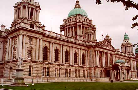
Heres our city hall:
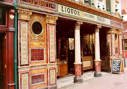
Here's the oldest bar in Belfast - The Crown:
And here's where I went to university - Queens University:

Okay, so here are some key events in Northern Ireland's history

Ireland has been divided administratively since 1922 when the Irish Free State was formed
12th century.
First involvement by England in Irish affairs when the Earl of Pembroke, known as Strongbow, intervenes in a local dispute in Leinster in 1170 . King Henry II lands the following year.
English expansion continues and in 1177, Ulster is conquered by soldiers led by John de Courcy.
14th/15th centuries English expansion halted and then reversed. By the end of the period, English possessions are limited to a small area around Dublin. the 'Pale'. Everything outside is regarded as savage, giving rise to the expression 'beyond the pale'.
16th century First Henry VIII and then Elizabeth I take an increasing interest in Ireland. Colonisation increases again, sparking off several rebellions late in the century.
The greatest of the revolts, led by Ulsterman Hugh O'Neill, the Earl of Tyrone, reaches its high point with victory over the English at the Yellow Ford in 1598, but he is defeated three years later at Kinsale and surrenders.
17th century Start of the 'Plantation of Ulster' - the systematic colonisation of Donegal, Tyrone, Derry, Armagh, Cavan and Fermanagh by settlers from England and Scotland.
After Parliament's victory in the English civil war, Oliver Cromwell conquered the whole of Ireland and set about opening the island up to colonisation.
1690 Protestant King William of Orange's troops defeated the Catholic army of King James at the Battle of the Boyne to confirm his claim to the English throne and with it Ireland.
By the end of the 17th century, Ulster in particular was heavily settled, mainly by Scottish Presbyterians.
1912 Amid a growing home rule campaign, the Ulster Unionist leader, Sir Edward Carson, sets up the original Ulster Volunteer Force as a bulwark against Dublin's domination of the Protestant-majority 'six counties' in the north of Ireland. Carson is still regarded by many as the founder of the state of Northern Ireland.
1916 The Easter Rising. Pro-home rule Irish rebels seize the Post Office building in the centre of Dublin but are eventually ousted by British soldiers. Fifteen of the rebellion's leaders are executed. Carson's UVF, which had become a division of the British Army, fights in France and a thousand die at the Somme.
 (Michael Collins) (Michael Collins)
1921-22 The first Northern Ireland Parliament opens
After a long and bitter guerrilla campaign against the British Army, Ireland is granted partial home rule.
The Irish Free State is set up in the southern 26 counties of Ireland. Its architect, Michael Collins, is assassinated during the ensuing civil war between his Free State forces and the IRA, which refuses to accept the partition.
(Michael Collins)
The war ends after the new Irish Government executes IRA leaders.
1939-45 Irish Republic remains neutral in World War II while Northern Ireland becomes an important Allied sea and air base.
1949 Ireland becomes a full republic and the British government gives new constitutional guarantees to the Northern Ireland Parliament at Stormont.
1952 The Official IRA calls off a series of attacks on Royal Ulster Constabulary police stations near the Irish border which cause few casualties and generated little publicity.
1956 The IRA launches a border campaign which leads to the introduction of internment of suspects without trial both in the Republic and in Northern Ireland.
1968 The civil rights movement begins the campain for equal rights in housing and voting for poorer Catholics. Protestants counter-demonstrate.
1969
March:The RUC is armed in border areas for the first time since 1965.
August: The province's Catholic minority welcomes British troops, sent to Northern Ireland in response to an upsurge in sectarian violence. The Provisional IRA (the 'Provos') breaks away from the Official IRA, which is criticised for failing to protect Catholic enclaves.
1970
August: The Social Democratic and Labour Party (SDLP) is formed to press for Catholic civil rights. By now the British Army is being seen as an army of occupation by many Catholics and several soldiers are shot dead by the IRA.
October: The former Irish Finance Minister, Charles Haughey, is found not guilty of illegally importing arms. It was alleged he planned to send the weapons across the border to arm nationalists. Mr Haughey, later to become Prime Minister of the Republic, becomes a hate figure for Unionists in Northern Ireland.
1971
February: First soldier shot dead in Northern Ireland since troops arrived in August 1969.
August: Internment without trial is introduced. Hundreds of suspected extremists, including the present Sinn Fein President, Gerry Adams, are rounded up and detained over the next four years.
December: 15 people are killed in an attack on a Belfast pub. The Ulster Volunteer Force claims responsibility.
1972
Thirteen catholics were shot dead by British troop on 'Bloody Sunday'
January: 'Bloody Sunday': Thirteen Catholic protesters die after being shot by troops from the 1st Battalion the Parachute Regiment following disturbances during a banned civil rights march in Londonderry.
March: Edward Heath's Conservative government imposes direct rule on the province, creating the post of Northern Ireland Secretary, and closes the Unionist-dominated Stormont Parliament in a concession to republicans. The Ulster Unionist Party breaks off formal links with the Conservative Party in protest.
The IRA declares a temporary ceasefire and several republican leaders, including Gerry Adams, are flown to London for secret talks with the Government, which come to nothing.
July: Nine people are killed when 22 bombs explode in Belfast. This became known as 'Bloody Friday'. The IRA was held responsible.
1974
January: The Government sets up a power-sharing executive, in which posts are handed out on a quota basis, in a bid to include Catholics in the decision-making process and end the much-resented Unionist domination.
May: In Dublin, 22 people are killed by car bombs which explode without warning. Five people are killed by a car bomb in Monaghan Town. Three more people die later from their injuries. Loyalist paramilitaries are thought to have carried out the attacks, although the UDA and the UVF deny they were involved.
Protestant workers all over Northern Ireland go on strike in protest at the power-sharing executive plus a proposed council of all Ireland. It promptly resigns and direct rule is reimposed.
October: Five people killed as IRA bomb wrecks a pub in Guildford, Surrey, frequented by soldiers. IRA attacks another pub also used by soldiers in Woolwich, south east London.
November: Twenty-one people killed by two IRA bombs planted in two pubs in Birmingham.
1975
October: In a series of UVF attacks, 12 people are killed and 46 people injured. The UVF is declared an illegal organisation.
November: A gang of loyalists, known as the Shankill Butchers, abduct and murder a Catholic reveller as he walks home through west Belfast.
December: Internment is lifted by the new Northern Ireland Secretary, Labour's Merlyn Rees.
1977
May: The Second Ulster (Protestant) Workers' Strike peters out.
1978
February: 12 people are killed and 23 injured in an IRA bomb attack on a hotel in County Down.
1979
Eleven members of the so-called 'Shankill Butchers', are given life sentences by a Belfast court for a series of sectarian murders.
March: Airey Neave, Conservative MP and shadow Northern Ireland Secretary, is killed by a bomb attached to his car in the House of Commons car park by the Irish National Liberation Army (INLA), the military wing of the Irish Republican Socialist Party, an IRA splinter group.
Lord Mountbatten, killed by the IRA
August: Lord Mountbatten, last Viceroy of India and uncle of the Prince of Wales, is killed by an IRA bomb on his boat off the coast of County Donegal in the Irish Republic.
On the same day an IRA bomb explodes under an Army bus at Warrenpoint, County Down. A second bomb goes off as the survivors clamber out of the bus and onto an Army helicopter.
Eighteen soldiers and one civilian die. It is the Army's biggest single setback since the IRA campaign began.
1981
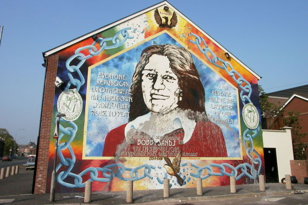 (Mural of Bobby Sand on the Falls Road - a Nationalist/Catholic area) (Mural of Bobby Sand on the Falls Road - a Nationalist/Catholic area)
Bobby Sands became a republican martyr in 1981
May: Bobby Sands dies in the Maze Prison after a prolonged hunger strike. He is the first of 10 IRA and INLA prisoners to starve to death. They were protesting, in vain, for the right to be considered prisoners of war rather than criminals.
1984
October: Five people are killed and 30 injured when an IRA bomb explodes at the Grand Hotel in Brighton during the Conservative Party conference. The Conservative Prime Minister, Margaret Thatcher, narrowly escapes death and the party Chairman, Norman Tebbit, is seriously injured.
1985
November: The Anglo-Irish Agreement is signed by Mrs Thatcher and the Irish Taoiseach, Garret FitzGerald, setting up a number of cross-border initiatives. It is opposed by many Ulster unionists. Thousands turn out in Belfast to cheer Reverend Ian Paisley's famous 'No Surrender' speech against the agreement.
1987
November: Eleven killed by an IRA bomb which explodes during a Remembrance Service in Enniskillen, County Fermanagh.
1988
March: Three IRA members are shot dead by British special forces in Gibraltar, where they are allegedly planning an attack on the British garrison.
Nine days later, during their funeral, a lone loyalist gunman, Michael Stone, kills three mourners in a gun and grenade attack on the Milltown cemetery in west Belfast.
Four days later two soldiers in civilian clothes drive into the funeral cortege of one of the IRA men killed by Stone and are abducted, beaten, stripped and shot dead.
1989
September: Eleven army bandsmen are killed when a bomb explodes at the Royal Marines School of Music in Deal, Kent.
1990
July: Conservative MP Ian Gow, a strong supporter of the unionist cause, is murdered by an IRA bomb at his Sussex home.
1992
April: An IRA bomb outside the Baltic Exchange building in the City of London kills three.
1993
March: Two children, aged three and 12, are killed by an IRA bomb planted in a rubbish bin in the centre of Warrington, Cheshire.
October: Loyalist gunmen storm into the Rising Sun bar in Greysteel, County Londonderry shouting "trick or treat" and open fire on drinkers, killing six men and two women.
1994
July: Several people, including a man in his 80s are shot by loyalist gunmen as they watch the Ireland v Italy World Cup match on television in a pub in the predominantly Catholic village of Loughinisland, County Down.
August: IRA announces a complete cessation of violence.
October: cessation of loyalist hostilities announced by the Combined Loyalist Military Command.
1995

US President Bill Clinton shakes hands with Gerry Adams
December: President Clinton visits Northern Ireland and shakes hands with Gerry Adams.
1996
February: The IRA calls off its ceasefire and one hour later sets off a bomb at South Quay near Canary Wharf in London's Docklands which kills two, injures 100 and causes millions of pounds' worth of damage.
The Docklands bomb brought to an end the first IRA ceasefire
A few days later another bomb explodes prematurely on a bus in Aldwych, central London, killing eight people including the bomber.
June: A huge IRA bomb destroys Manchester's Arndale Centre but no-one is killed.
July: A march by Orangemen is blocked by the RUC at Drumcree, near Portadown, as it approaches the Catholic Garvaghy Road area. After a stand-off, the RUC then makes a U-turn and permits the march, sparking violent clashes between Catholics and the police in Portadown, Belfast and Londonderry.
A few days later 40 people are injured by a bomb at the Killyhevlin Hotel in Enniskillen. Responsibility is claimed by the extremist republican Continuity Army Council.
August: Northern Ireland Secretary Sir Patrick Mayhew bans loyalist Apprentice Boys from marching along contentious sections of Londonderry's city walls for the traditional Siege of Derry celebration. Loyalist leaders pull back from a confrontation with security forces.
October: An IRA bomb explodes at the Thiepval Barracks in Lisburn, killing a British soldier.
1997
February: Corporal Stephen Restorick is shot dead by an IRA sniper at a checkpoint in south Armagh.
April: IRA bomb hoaxers cause havoc on Britain's motorways, especially the M6 in Birmingham and the M1 in Northamptonshire.
July: IRA declares another ceasefire. UUP leader David Trimble meets Tony Blair in Downing Street. At a news conference afterwards, Mr Trimble announces that the Unionists are unhappy with the talks proposals and will not support the Government on the decommissioning vote. Ian Paisley meets Tony Blair and claims the talks process was 'dead in the water'. First Sinn Fein-Government meeting since the restoration of the IRA ceasefire.
August: Gerry Adams and Mo Mowlam (Northern Ireland Secretary) meet at Stormont for the first time since the ceasefire. Mo Mowlam announces that Sinn Fein will be admitted to the peace talks.
September: Sinn Fein affirms its commitment to the Mitchell principles of democracy and non violence but the Unionists remain unconvinced. These guidelines are named after the former American senator George Mitchell who chairs the political talks process. The six principles include the total disarmament of all paramilitary organisations and the end of the so-called punishment killings and beatings.
The deadlock is broken as the parties concerned strike a deal opening the way to peace talks.
October: For the first time in 25 years unionists, loyalists, nationalists and republicans sit together to seek a solution to Ulster's problems. Tony Blair shakes hands with Sinn Fein's Martin McGuinness and Gerry Adams. He becomes the first British Prime Minister for 70 years to meet a Sinn Fein delegation. Unionists react angrily.
The Ulster Freedom Fighters (UFF) withdraw from the Combined Loyalist Military Command, the umbrella group for loyalist paramilitary groups.
The Northern Ireland Secretery Mo Mowlam gives wider powers to the Northen Ireland Parades Commission. The intention is to halt or re-route flashpoint marches. Nationalist residents groups called for the disbandment of the commission.
December: Gerry Adams and Sinn Fein delegation meet Prime Minister Tony Blair at Number 10 Downing Street, he is the first Irish Republican leader to visit Downing Street since Michael Collins visited Lloyd George in 1921.
Londonderry experiences its worst violence since the restoration of the IRA ceasefire in July, when riots break out as nationalists protest at a Protestant Apprentice Boys parade through the city centre.
The Northern Ireland Secretary orders a full inquiry into how a republican prisoner managed to escape from the high-security Maze prison despite the recent tightening of security.
Billy Wright, one of Ulster's most feared loyalist paramilitaries, is shot dead at the top security Maze prison in Northern Ireland. His Loyalist Volunteer Force carry out a series of revenge shootings - one within 24 hours and another on New Year's Eve.
1998
January: The peace process is in danger of collapsing as loyalist prisoners in the Maze withdraw their support for the talks.
Mo Mowlam gambles on a historic face-to-face meeting with the prisoners inside the Maze. It works and the loyalist inmates announce renewed support for the peace process. Two days later another Catholic is murdered by LVF gunmen. The victim, Terry Enwright, is married to a niece of Gerry Adams.
After a period of violence in which a total of seven Catholics and two Protestants die, the loyalist Ulster Democratic Party leaves the peace talks when one of the groups to which it is linked, the Ulster Freedom Fighters, admits some of the killings.
February: Two men are killed and the IRA is blamed by RUC chief constable Ronnie Flanagan. As a result, Sinn Fein is suspended from the peace talks until March 9 despite arguing that it does not represent the IRA. Sinn Fein says it might not return to the table and insists on a meeting with Tony Blair.
The UDP is readmitted to the talks after its suspension is lifted.
Ok, I'm done sounding like a history book. Long and short of it. The agreement was reached 27 hours after the deadline on Good Friday. It has restores 'normal' life and all is good!
____________

To err is human, to arr is pirate.
|
|
Consis
Honorable
Legendary Hero
Of Ruby
|
 posted March 28, 2004 04:52 PM
 |
|
|
Question About Ireland
Asmodean,
I don't understand. So the terrorist group, IRA, bombs targets of signifigance for what reason? To get the British out of Ireland? Do the British still have some kind of rule over the Irish people? I don't understand.
____________
Roses Are RedAnd So Am I
|
| |
|
|


